Risk Management
Risk management is an integral part of the quality management of the ISCC system and component of all decision-making processes within ISCC.
ISCC defines a procedure and specific indicators for risk assessment and management to ensure compliance with the requirements of the certification system with high levels of credibility and reliability. The procedure is an integral part of all operations and decisions in the ISCC system applicable to ISCC, the recognised certification bodies (CBs) and ISCC system users.
Risk management means the overall process of risk assessment (identification and evaluation of the risk) followed by the identification and implementation of risk control measures to reduce the probability and/or the negative consequences associated with a risk. Therefore, the risk management process within the scope of ISCC is carried out in two main steps:
1. Risk Assessment
- Identification,
- Evaluation, and
- Classification of risk level and risk factor.
2. Identification and Implementation of Appropriate Risk Control Measures
ISCC promotes new developments, tools and other measures to improve the risk management process. This includes for example the use and application of risk assessment tools e.g. for remote sensing analysis, to assess land use change and other land related sustainability criteria, or databases improving the traceability of sustainable material and the respective sustainability claims and thus reducing the risk of fraud. One of the innovative tools ISCC is using for its risk assessment is GRAS – Global Risk Assessment Services.
GRAS – Global Risk Assessment Services
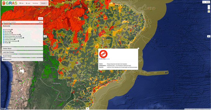
GRAS is a tool providing comprehensive sustainability-related geo-referenced information on biodiversity, land use change, carbon stock and social indices. GRAS provides a compilation of different layers from national and international databases on biodiversity. The information is immediately available and presented in a very user-friendly way. Below, Brazil is shown as example. The maps differentiate clearly between no go and risk areas. This helps to conduct the risk assessments, and saves time and costs in audits.
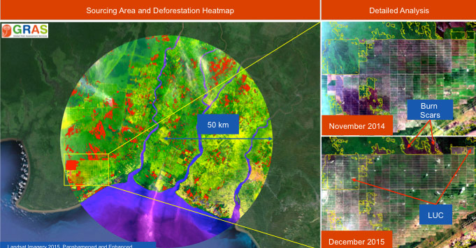
GRAS also provides carbon maps and important information regarding social issues on a country (and partly regional) level. A key functionality is the detection of land use change. Auditors and companies use GRAS to verify the occurrence of land use change by using a simple to interpret, yet powerful, greenness index called Enhanced Vegetation Index

(EVI). Using EVI time series from 2000 until today, GRAS users can differentiate among the types of green cover, see the history of the land use, and most importantly detect the exact point in time of LUC. It enables the user to identify deforestation, replanting activities, grassland conversion and cropping activities (see examples in Fig 2. and 3). Combining ISCC with GRAS facilitates to conduct audits and increases at the same time the credibility of sustainability certification.
Further Information
ISCC EU 204 – Risk Management
The scope of this document covers the requirements on how the risk management process under ISCC is applied to all activities of ISCC and the implications of risks for ISCC audits.